문화예술특별시
지역문화지수 평가에서 우수한 문화자원과 기반을 인정받은 도시 '창원'

Muhaksan Hiking Trails
- AddressGyobang-dong, Masanhappo-gu, Changwon-si, Gyeongsangnam-do

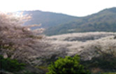
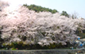
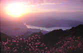
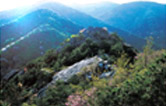
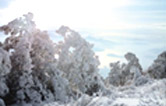
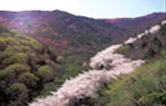
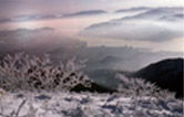
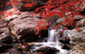
Muhaksan Mountain, seated behind Masan like a beautiful folding screen, is a beloved mountain by the residents of Changwon. It was given the name, “Muhaksan,” as it looks like a crane that is dancing with its wings spread open, but its original name was Ducheoksan. The main peak and Seomajigi are covered with silver grass, and the main ridge extends in the north-south direction. The western area of the mountain facing Gwangnyeosan Mountain is quite steep, whereas the eastern area has gentler slopes and embraces a part of Masan. The northern ridge connects to Cheonjusan Station in Changwon, and has gentle slopes that lead to Ducheokgol and Aengjibatgol. On the other hand, the southern ridge descends to Mannaljae via Daegoksan Mountain and extends all the way to Daesan Mountain. The beauty of Muhaksan Mountain is the Hakbong Peak, which is regarded as the “head of the crane.” The striking rocky peak looks spectacular with the azaleas that bloom in surrounding area in the springtime.
| Hiking Trails | Route | Distance | Duration |
|---|---|---|---|
| Trail 1 (Seowongok Trail) |
Seowongok entryway |
1 hr 50 min | |
| Trail 2 (Aengjibatgot Trail) |
Masan Girls’ Middle School |
2 hr | |
| Trail 3 (Mannaljae Trail) |
Kyungnam Univ. pedestrian overpass |
2 hr 30 min | |
| Trail 4 (Hakbong Trail) |
Seowongok entryway |
2 hr 10 min | |
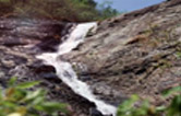
| Trail 5 (Wanwol Falls Trail) |
Wanwol Falls |
2 hr | |
| Trail 6 (Jung-ri Trail) |
Jung-ri Station |
3 hr |
Main Facilities Along the Hiking Trails