문화예술특별시
지역문화지수 평가에서 우수한 문화자원과 기반을 인정받은 도시 '창원'

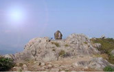
Jeongbyeongsan Hiking Trails
- AddressSarim-dong, Uichang-gu, Changwon-si, Gyeongsangnam-do

Jeongbyeongsan Mountain (567m) is the main mountain of Changwon that surrounds the city, and is situated between Toechon in Bongnim-dong, Yong-dong, and Dong-eup. It was called Jeondansan in the Goryeo Dynasty. The trail between Somok Hill and the summit is slightly steep, but generally speaking, the mountain features gentle slopes. It also offers a breathtaking view of the city as well as the Junam Reservoir at the summit.
| Hiking Trails | Route | Distance | Duration |
|---|---|---|---|
| Trail 1 |
Shooting Range |
7.1Km | 3 hr. 50 min. |
| Trail 2 |
Information Center |
3.7Km | 2 hr. 20 min. |
| Trail 3 |
Gilsangsa Temple |
5.8Km | 4 hr. |
| Trail 4 |
Dongeup Yongjeong Village |
3.6Km | 1 hr. 50 min. |
| Trail 5 |
Dong-eup Jayeo Village |
3.8Km | 2 hr. |
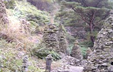
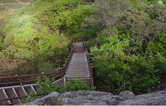
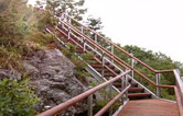
Main Facilities Along the Hiking Trails